
Talbot Thrive’s Response to Proposed SHA Matthewstown Road Redesign
” In April of 2024, the Maryland State Highway Administration presented the proposed options for the redesign of the Matthewstown Road corridor from Black Dog Alley to Rt. 50. Our objective here is to offer our analysis to ensure that the plan takes into account the needs of all individuals who use the road now and who will be using it in the future. Review the design plans here or click on the report cover (at right) to view the PDF. Per the SHA website, the “purpose of the study is to assess the transportation needs along MD 328, including traffic operations, safety and pedestrian and bicyclist accommodations.”
This projects represents a “statement entrance” and wonderful opportunity to highlight the town of Easton for residents and visitors traveling into Easton from the east. We know our rural communities are disconnected from resources, with no sidewalks, no public transportation or multi-use paths and therefore, we had hoped this project would serve as a forward-thinking model for future byway construction in our community, prioritizing the needs of pedestrians and cyclists over the movement of cars, unfortunately it comes up short.

Talbot Thrive believes that now is our chance to plan for housing developments and increased users of all types along this corridor. The existing access to homes along the route and the increase in vulnerable road users necessitates a solution that transforms this route into a street, rather than a road. The entry to the Town of Easton from the east should be marked with a roundabout at Black Dog Alley and a planted median, signaling slower speeds and entry into a community of neighborhoods requiring driver attentiveness. As housing developments are constructed along this corridor, each should feature a roundabout for entry and exit as well as clear design choices to slow traffic. What is a roundabout and why is the design safer and beneficial in this case? Review the State of WA description and “rules of the road” for roundabouts.
Referring to the Global Street Design Guide, we know that “design speed is the target speed at which drivers are intended to travel on a street, and not, as often misused, the maximum operating speed. As numerous planners and studies have documented, drivers travel at the speed that they feel most comfortable given the width of the road, real or implied impediments to speed (e.g., curside bumpouts and pinchpoints, trees, crosswalks, etc) and NOT the posted speed limits. Therefore, actively designing for target vehicle speeds is critical to safety. Changing a street’s design results in behavior changes. Practitioners must manage speeds by setting clear expectations for drivers.” What is the proposed design speed for this section of street?
Developed with the input of experts from 72 cities in 42 countries, the Glocal Street Design Guide is intended to inform “street design that prioritizes pedestrians, cyclists and transit riders. A proactive approach selects a target speed and uses design to achieve that speed, guiding driver behavior through physical and perceptual cues. These cues include narrower lane widths and tighter curb radii, signal progressions, and other speed management techniques. Using lower design speeds in street design reduces vehicle speed and speed variation, providing safer places to walk, cycle, drive, and park.” Ideally, the use of narrower lanes, planted medians and roundabouts would be the preferred devices used to control speed, not simply reducing the speed limit and making the route prioritized for the speed and efficiency for cars.
Is there a fear of pushback from the “commuting public” who use this well-traveled route into the Town of Easton? That comprehensive road design which accommodates all users will slow their travel times by 5, 10 even 15 minutes? Allow us to counter that complaint with compelling evidence that indicates there is generally no substantial rise in delays when road space is reduced to accommodate bikes, pedestrians, and even buses.
To debunk the idea that traffic will slow and that drivers will seek out alternative routes to get around an area they perceive as congested we refer to the transportation engineering and design firm Kittleson and Associates article titled “Myth Busters: Does Removing a Travel Lane Increase Cut-Through Traffic?” which states “Many roadways have benefited from reallocating roadway space for other modes by reducing the number of vehicular lanes. These reallocations result in comparable daily traffic volumes and delays before and after the road diet (i.e., a reduction in the number of lanes for automobiles), a surprising outcome to many roadway users.”
In light of the town’s expansion and the addition of new developments on its outskirts, it is imperative that we establish protocols regarding the treatment of vehicles entering through this perimeter and the expected conduct from them.
According to their research, in Fort Lauderdale, Florida, Powerline Road was reallocated from six lanes to four lanes with buffered bike lanes. Results include increased bicyclist activity, minimal to no change in travel times, and increased economic activity, without increasing traffic on adjacent roads. In Alexandria, Virginia the redesign of a major artery to include bike lanes and traffic calming showed travel times across the day were generally consistent with the prior roadway configuration, while walking and biking activity had increased along the roadway.
In the case of MD 328, we ask that center turn lanes and designated turn lanes which are included in the proposed redesign be eliminated in favor of the continuation of the pedestrian and bicycle facilities all the way to the Rt. 50 interchange. We would also like to recommend that roundabouts be used whenever possible at intersections. Roundabouts slow and moderate traffic speeds, whereas traffic lights can sometimes encourage “beat the light” driving behavior. Roundabouts maintain a smoother overall traffic flow, reduce intersection waiting times, and minimize vehicle idling and they are potentially more environmentally and aesthetically friendly, with abundant evidence proving they are safer than traffic lights. Given the paramount importance of safety, it’s clear why roundabouts should be preferred, however, some drawbacks include increased land use and a community learning curve when a new roundabout is installed.
Due to anticipated housing developments between RT. 50 and Black Dog Alley, the only safe and responsible redesign of the road should anticipate increased car usage, more pedestrian usage and the opportunity for all vulnerable road users to share equally in the corridor.
With the lack of a Complete Streets Design for the Town of Easton and ownership of MD 328 by the State, we ask that project managers take into account the concerns expressed here for all road users. In light of the recent establishment of MDOT 750 Complete Streets Guidelines we are encouraged that the SHA will be given an opportunity to redesign the corridor with those guidelines in mind.
Commentary on specific intersection design is below:
Page 12
Intersection Concept 1 (Rt. 328 at US 50 and Elliott Rd.):
- Option A – Lengthen turn lanes to ease car congestion. (“US50 Corridor pedestrian and safety project will add sidewalks and crosswalks to US50 in 2026”)
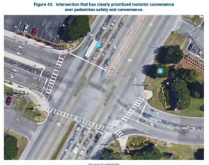
TT Comment: No bike or pedestrian facilities are shown in the proposed design. The connection for pedestrian facilities that will be added in 2026 are not shown or non-existent in the plan. In fact, the plan shows nowhere that pedestrians can safely walk on either side of Matthewstown Rd. once Rt. 50 is traversed. See 1. and 2. on figure below as well as Figure 43, bottom below, from NCHRP Report 926, Guidance to Improve Pedestrian and Bicyclist Safety at Intersections. (20) which states “Figure 43. Intersection that has clearly prioritized motorist convenience over pedestrian safety and convenience.” Figure 43. shows a very similar intersection to that we are discussing at Rt. 50 and 328.
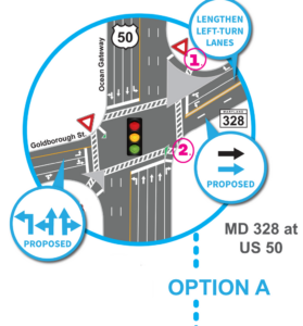
In addition to the lack of pedestrian connectivity (does the area marked above #1. link to a sidewalk on Matthewstown Rd.?) there is a lack of a separated or marked bicycle lane for crossing Rt. 50. But 5 lanes to accommodate car users and keep them moving efficiently.
TT strongly advises the design group to take into consideration the fact that people who use bicycles as their primary means of transportation are left out of this plan. For this reason, Option A (we see no other options) is unacceptable.
Page 13
Intersection Concept 2 – 328 at Gannon Circle
Option A – Add a dedicated left-turn lane in Westbound direction
TT Position: Ideally this would also be a roundabout to slow traffic and allow for safe access for Gannon Circle residents to merge onto 328 in either direction
“When you get into that middle area, where you’re traveling 30 or 40 mph, you’re really not going anywhere at a speed that is meaningful, but you’re also not building a place that can actually function or sustain itself financially—a place that anyone really wants to be in.” Link
Intersection Concept 3 – 328 at Mile Post Drive
Option A – Add a dedicated left-turn lane in Eastbound direction
TT Position: Ideally this would also be a roundabout to slow traffic and allow for safe access for Mile Post Drive residents to merge onto 328 in either direction
Page 14
328 at Dyott Court and Fisher Range Rd.
Option A – One dedicated turn lane concept
Option B – Two dedicated turn lane concept
TT Position: Ideally, this would have been the perfect place for a roundabout but we are certain there is not enough land at this point to accommodate that type of design. A circle here would enforce slower approaches, one lane of travel in all 4 directions AND a shared multi access path for bike and pedestrian travel.
Page 15
Intersection Concept 5 – 328 at Black Dog Alley
Option A – Dedicated Turn Lanes
Option B – Roundabout
TT Position is in the support of a roundabout here as long as pedestrian and bicycle facilities are part of the mix. A roundabout at this location would allow for a proper sign to introduce drivers to the Town of Easton as well as encourage drivers to slow down as they enter a corridor with multiple avenues of entrance or exit. With an exclusion of large trucks on Black Dog Alley, this will further impede their speed and eventually discourage them from using the road as a cut through.
Page 16-17
Corridor Concept 1 Bicycle and Pedestrian Routes
- Option A – Add sidewalks on both sides of MD 328 and bike lanes on the shoulders
- Option B – Add 10 foot shared path on the North side of Matthewstown Rd.
- Option C – Add 10-foot shared use path on both sides of MD 328 buffered by 4’ curb and gutter
With the 12’ requirement for travel lanes on State Roads in Maryland, this limits controlling speed using lane narrowing devices. A design which includes a planted median buffer, not center turn lanes, separate facilities for both pedestrians and people on bikes would be the only option that Talbot Thrive could support. Traffic circles wherever possible as well as speed enforcement would be needed in conjunction with design.
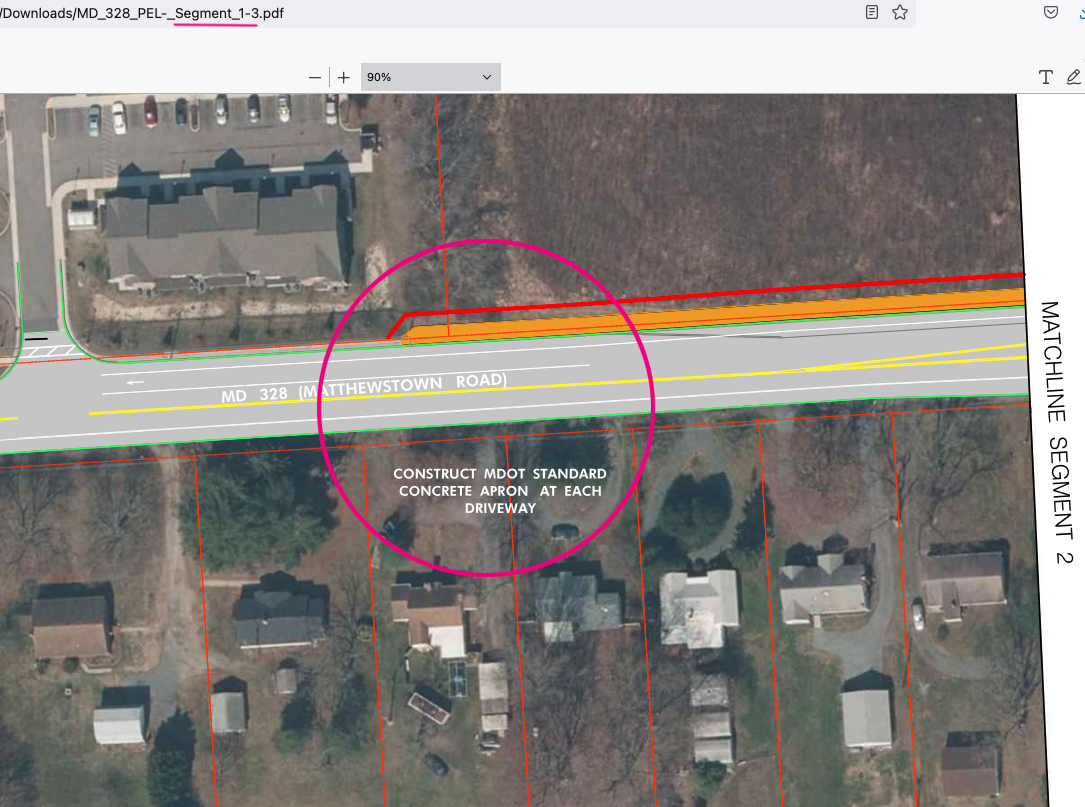
MD_328_PEL-_Segment_1-3.pdf shows that the proposed bike and pedestrian route ends before the turn off for Galloway Meadows on the North Side of MD 328. This proposed design forces people on bikes to use the sidewalks, which is illegal in Maryland, or into one of the travel lanes from that point until Rt. 50. This is unacceptable as the study has already established that this corridor is LTS (Level of Stress Test) of 4 indicating that it is only suitable for “Strong and Fearless” bicyclists. The plan that MDOT has presented here does nothing to improve safety for people who use bicycles as their main means of transportation.
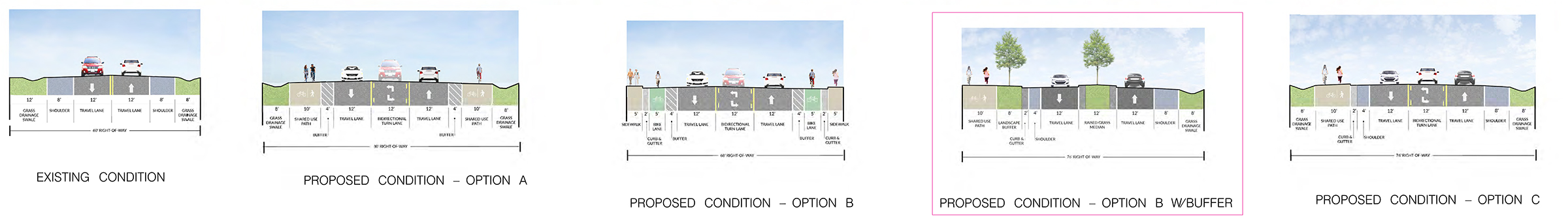
MD_328_PEL-_Segment_3-3.pdf shows the cross sections below. The Talbot Thrive position is that Proposed Condition Option B with buffer is the closest to a design that would be safe and accessible for all users, however the design needs separate and dedicated lanes for pedestrians and cyclists. Putting cyclists on the same path and same direction as pedestrians only creates confusion and the requirement that cyclists cross the road (sometimes 2X) to get where they need to go. This requirement would remove the center turn lane but has the advantage of lowering speeds and providing the conversion of this corridor to a street, instead of a road.
Page 19
Preliminary Concepts:
- Option A – Reduction in Speed limit from Black Dog Alley
- Option B – Roundabout Intersection at Black Dog Alley
- Option C – Median Islands to reduce speed
TT position: While we typically advocate for lower speed limits, we believe that in this instance, the road design in this corridor should encourage drivers to reduce their speed. All three options should be considered in the design plan here, with roundabouts at all intersections which can accommodate them.
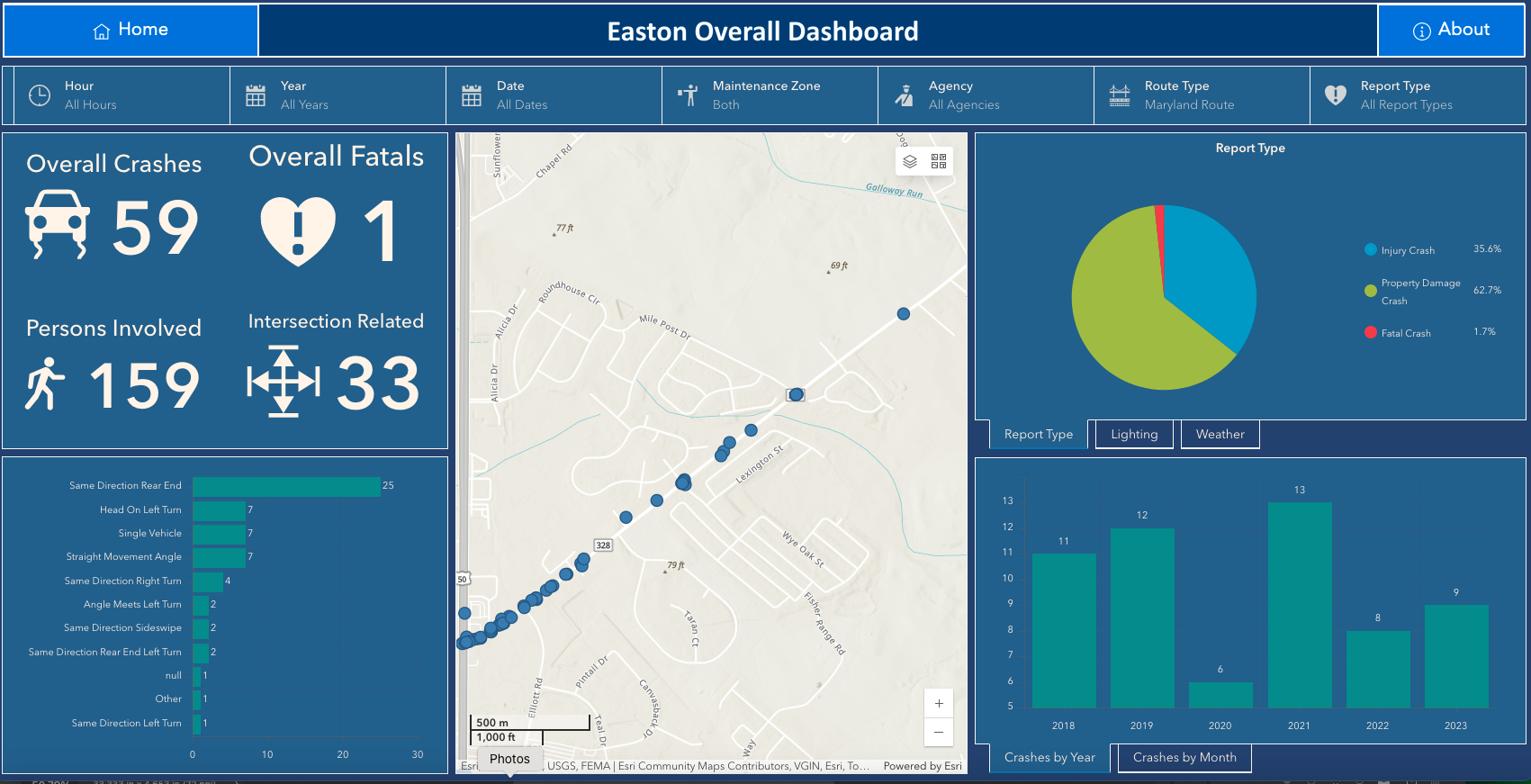
Crash Data Shows almost 60 accidents, one fatal, along this corridor from 2018-2023
At this stage, it is crucial to plan for an increase in all users along this corridor. By paying particular attention to the most vulnerable road users, we can enhance safety and promote a more equitable experience for everyone.
References:
Global Street Design Guide, The Bloomberg Foundation, https://globaldesigningcities.org/publication/global-street-design-guide/design-controls/design-speed
Myth Busters: Does Removing a Travel Lane Increase Cut-Through Traffic?
https://www.kittelson.com/ideas/myth-buster-cut-through-traffic/
Powerlane Road Repurposing Before and After Study https://fdotwww.blob.core.windows.net/sitefinity/docs/default-source/planning/fto/mobility/powerlinerd-beforeafter.pdf?sfvrsn=c18c7084_2
Bringing a Complete Street on Seminary Road
https://media.alexandriava.gov/docs-archives/tes/info/seminary-presentation.pdf
Additional Reading
Smart Growth America “Why Safety and Speed are Fundamentally Incompatible”
https://smartgrowthamerica.org/why-safety-and-speed-are-fundamentally-incompatible-a-visual-guide/
Strong Towns, “The Key to Slowing Traffic is Street Design, Not Speed Limits”
MD 750 Complete Streets
https://policymanual.mdot.maryland.gov/mediawiki/index.php?title=MDOT_750_Complete_Streets